Fancy a walk around Granada?
You should know that it is one of the Spanish cities with the most fountains per inhabitant. It is crossed by 3 small rivers and has been supplied by many irrigation channels. Its proximity to the mountains even allows the existence of some springs near the city. And to top it all the quality of its water is exceptional.
For this reason it deserves a post about walks and walks along the water in Granada.
What you will find here
LA CUESTA DE LOS CHINOS
We start with one of the most delightful walks in Granada, for us this is one of those special places. This slope, also called the slope of Rey Chico or Los Molinos, climbs up the Fuente Peña ravine. Although naturally this ravine would not have a permanent watercourse, since medieval times surplus water from the Alhambra has been discharged here.
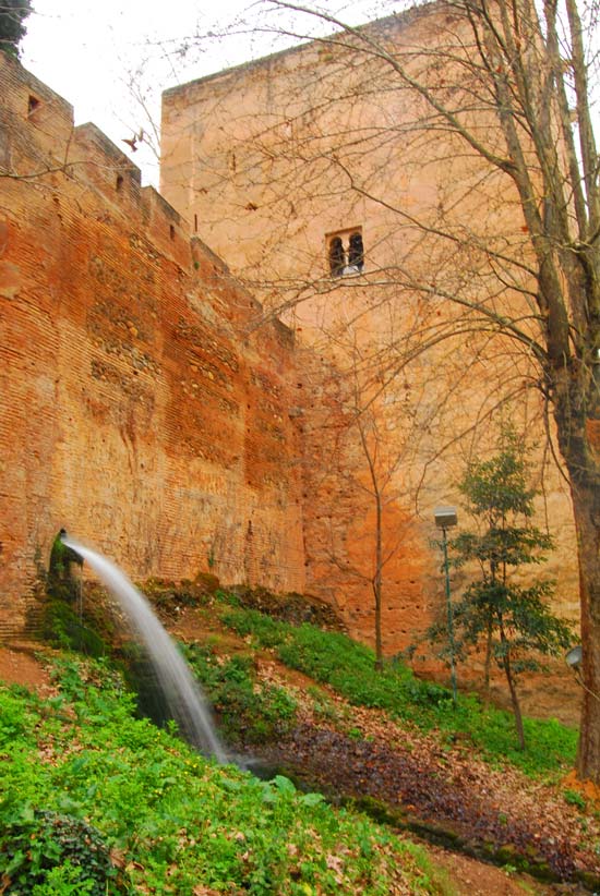
Surplus water from the Royal irrigation channel of the Alhambra flows into the ravine of Fuente Peña.
The ascent is made at the foot of the wall and under the imposing presence of the calahurras (palace towers) of the Alhambra. We ascend alongside a constant stream of water and surrounded by vegetation and high walls.
To all this we must add that this was a place related to the palace intrigues of the Nasrid court. Isabel de Solís was held captive in one of the high towers and it was up this slope that the Little King, Boabdil, fled to rebel against his father. But we will tell you about this in another post later on.
How to get to the cuesta de los Chinos?
Very easy. From Plaza Nueva to Paseo de los Tristes on foot. Once there, at the end of this walk there is a small bridge that crosses the Darro (the Aljibillo bridge). Then you will see a slope that goes up between buildings. Do not confuse it with the slope on the left that leads to the Avellano fountain. At the end of the post, and as usual, we leave you a map with the location of each place.
Drinking water at the cuesta de los Chinos
There are no water fountains on the cuesta de los Chinos, but there are at the beginning of the Paseo de los Tristes and at the end, at the ticket offices of the Alhambra.
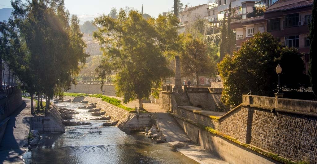
CARRERA DEL DARRO
This peculiar street in Granada along the Darro River is one of the icons of Granada. The river runs between the Albaicín and the Alhambra. It is not very fast-flowing, but in its course we find lush vegetation in spring and summer.
Several stone bridges cross it and it is dotted with monuments, temples and museums. On both sides are medieval dwellings and Renaissance and Baroque mansions. Some of them are decorated with Classicist trompe l’oeil.
Despite the Albaicín’s Andalusian past, this street was shaped from the 16th and 17th century onwards, with the walls being demolished to create a passageway. However, there are many monuments of Andalusian origin that survive in the area: the Tableros gate (incorrectly called the Cadí bridge), the Bañuelo, the Maristán, the house of Zafra and some private homes.
The magic of Granada is evident here. This space is one of the reasons why Granada is considered to be one of the most beautiful cities in the world. As a result, you will find it very busy and even saturated. We invite you to run along the Carrera del Darro very early in the morning, before the sun rises over the Alhambra. It is a totally different experience.
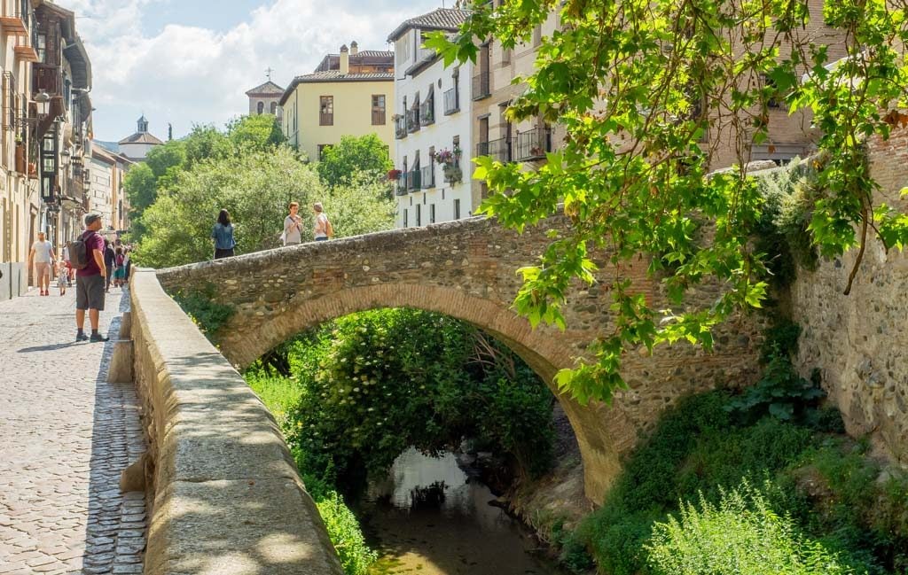
Cabrera Bridge in the Carrera del Darro(Ajay Suresh. Flickr. CC BY 2.0).
How to get to the Carrera del Darro?
Impossible to miss. It starts in the Plaza Nueva, next to the church of Santa Ana. It ends at the Paseo de los Tristes.
Drinking water in the Carrera del Darro
You can drink water at the beginning (Pilar del Toro in Plaza Nueva), towards the middle of the route (Pilar del Convento de Zafra) and at the end in the current fountains of the Paseo de los Tristes.
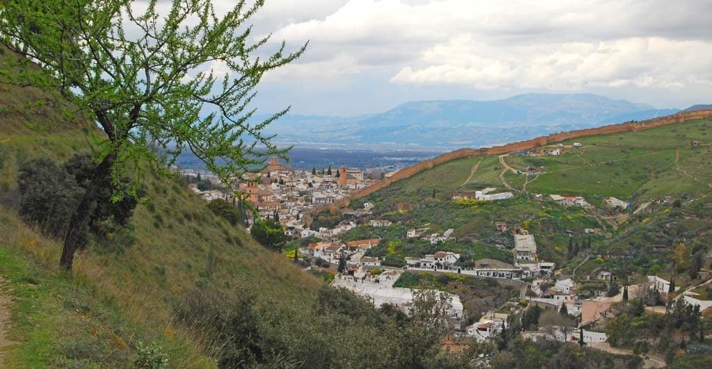
LA ALHAMBRA FOREST
The central street of the Alhambra Forest is crossed by two small water channels, one on each side. Although the path is steep, the surroundings mitigate any fatigue, especially in spring and autumn.
But don’t think that this forest has always been here. The current appearance of the Alhambra’s surroundings does not correspond to the appearance it had during the Middle Ages. The Alhambra, although a palace, was also a fortress. It was therefore necessary to have visibility around its walls.
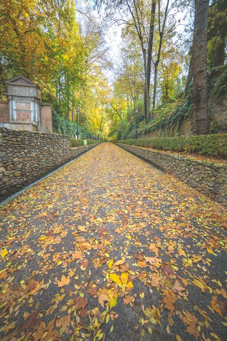
Beginning the ascent through the Alhambra Forest with water channels on both sides, any doubt that it is autumn?.
How to get to the Alhambra Forest?
In the 16th century and under the reign of Charles V, a large part of the current forest was planted. Later (17th century) the Marquis of Mondéjar increased the lushness of this space and provided it with paths. In time, the Tomate fountain and the spectacular Orejas gate (removed from the Bibrambla square) were added.
The predominant species is the horse chestnut tree, brought from America in the 19th century. It’s amazing to see this forest turn yellow in autumn, but be careful, the chestnuts are a real “chestnut” on windy days.
From Plaza Nueva we go up the slope of Gomérez until we reach the Alhambra Forest. Once through the Puerta de las Granadas, continue along the central path. A few metres away you will find the water channels.
Drinking water in the forest of the Alhambra
There are a couple of fountains today. One is next to the Tomate fountain, when we have already climbed the first stretch. Another one is at the end by the Pimiento fountain.
LAS ACEQUIAS DE LA ALHAMBRA
The sāqilla al-Sultān (Sultan’s irrigation channel) was built in the 13th century to enable the construction of the Alhambra and to provide it with water. The water is collected several kilometres upstream from the river. It meanders along the shady side of the Cerro del Sol until it reaches the Generalife. Its route is not very recommendable, as it has several very narrow stretches with considerable drops.
However, a few metres further up is the 16th century church. The route is the same, except at a higher elevation. Walking along this path is a delight at any time of the year. The irrigation ditch is partly built in a gallery, but it sometimes appears, especially when we approach the Alhambra.
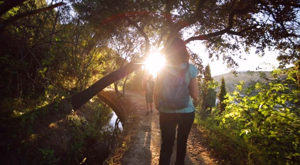
Bucolic path next to the Royal Ditch of the Alhambra.
The whole path has spectacular views. On one side is Sacromonte and on the other the Alhambra. In between are the Albaicín and the Cathedral of Granada. In front, the controversial Abadía del Sacromonte.
The sunset is the ideal time to enjoy this walk in Granada. If you go up the valley you will come to an area of very well-preserved woodland. Gall oaks, holm oaks, oaks and willows characterise this place. It is cool and humid all year round. It is home to eagle owls, ocellated lizards, foxes, and 19 different types of butterflies.
As you walk along the acequia Real, Granada is left behind.
How to get to the Acequia Real?
From the Alhambra car park you have to go up to the Silla del Moro. Once there, we enter the Darro valley, descending a little until we reach it. This whole area is full of paths that go up and down connecting the irrigation ditches and other paths. It is necessary to have some orientation, as in the shady area there is no telephone coverage.
We offer all the information you need to walk along the Acequia Real on your own, but if you feel like it, we will take you there and tell you the history of this place 👇.
“CAMINOS DEL AGUA”
It is an adventure and history route where we walk along several “Water Paths“, natural and artificial. We have designed it in order to know the history of water in Granada and to highlight the value of this fundamental element for life.
With this route we bring intrepid travellers to discover a part of the city that is little known and difficult to access if you don’t know the way.
The water of Granada is one of the best in the world, we don’t say so, its chemical analysis and renowned sommeliers say so, let’s value it and get to know its history!

WALK TO THE BICHA FOUNTAIN
On this delightful riverside walk Genil combines town and nature You will walk through wooded areas and along paths. You can also find some springs such as La Bicha and La Pita.
It starts in the town and reaches the Bicha spring on the left bank. However, the path could be continued for a further 6 km along the river until it reaches the neighbouring village of Pinos Genil. In fact it is from the Bicha fountain that the track becomes a path and we enter a riverside forest of poplars, poplars, willows and willows. The path climbs and descends gently without offering any great difficulty.
The river is crossed by wooden bridges from time to time. Through them you can access the right bank where the path is much wider, flatter and runs between the river and orchards.
The water from the spring of La Culebra, better known as the Bicha spring, has a slightly bitter taste due to the iron content of the soil. This is where the water carriers of Granada used to come to fill their jugs and take them to the city. To reach the fountain it is necessary to turn off the road and cross the road through a tunnel. The location is shown on the map.
Start of the walk to the Bicha fountain from Puente Verde.
How to get to the Fuente de la Bicha walk?
If you want to start from the city, just go to Puente Verde. From Gran Vía you can take bus number 33 (stop Gran Vía Colón 3) and it will leave you next to this bridge (stop Paseo de los Basilios 12). But if you want to skip the urban section you can continue on the same bus until a few stops further on (carretera de la Sierra 114). Once there, cross the road to the river and enjoy the walk.
Drink water at the Fuente de la Bicha walkway
You will find a fountain at the beginning of the path shortly after leaving Puente Verde. There is another one where the town ends next to a metal bridge. And further on there is the same fountain of La Bicha. The latter is not drinkable, but it is spring water.
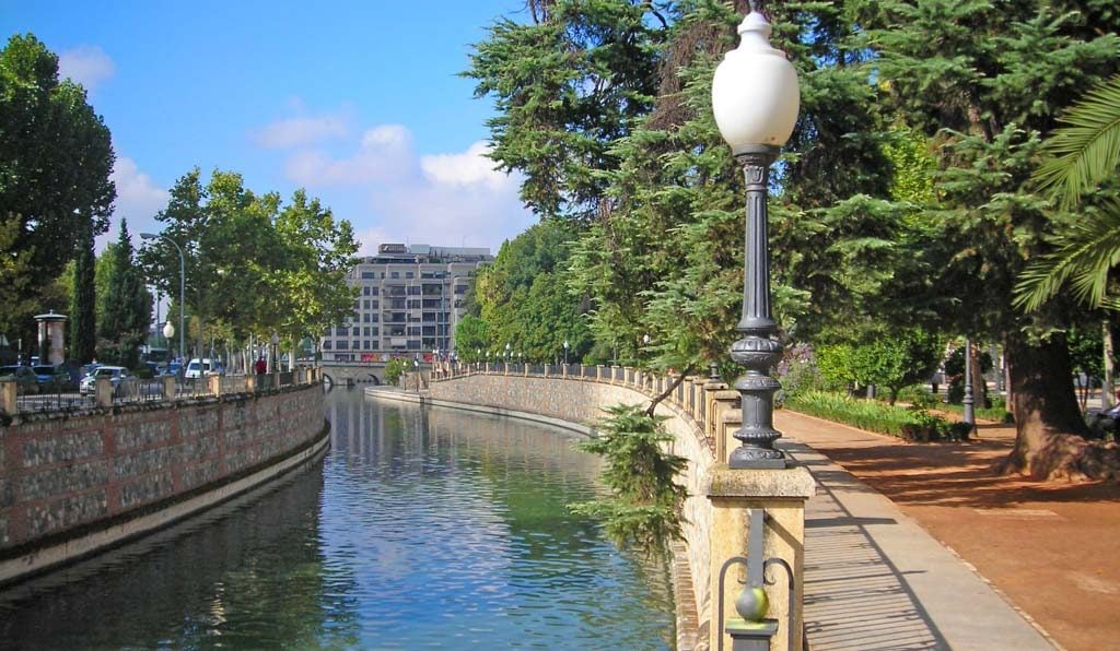
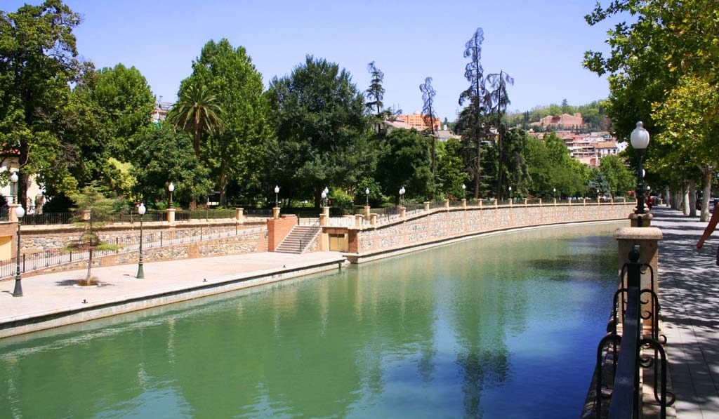
THE SALON WALK
This stately boulevard also runs alongside the river Genil, the largest river in Granada. Its water flows down from the 3 great peaks of the Sierra Nevada: Mulhacen, Veleta and Alcazaba.
The stature of its trees is astounding and on autumn days it is usually covered with a fluffy leafy canopy. The path is dotted with stone benches, Fernandino-style lampposts and ornamental fountains. It is not usually visited by tourists, yet it is one of the most beautiful places in the city.
Delicious walk along the Genil river (José Manuel. Flickr. CC BY-NC-SA 2.0).
The design of these promenades is related to the rise of the Grenadian bourgeoisie at the end of the 19th century. This incipient social class of merchants required European-style leisure areas. Although today we see them as classical spaces, at the time they were the image of modernity in Granada.
Next to the river we will find emblematic places of Granada such as the Kiosko las Titas, Puente Verde, the Monument to Flamenco and the popularly known Puente Romano.
There are three consecutive walks: the Bomba, the Salón and the Violón. In our opinion the Pump and the Salon are the most beautiful. They have more vegetation and are quieter. However, at the end of the Paseo del Violón is the Alcázar Genil. It is an old farmhouse from the Nasrid period that was located outside the medieval city walls.
Paseo del Salón with the water backing up at the Puente Romano (Tinette on it.wiki. Wikipedia. CC BY-SA 3.0).
How to get to the Hall’s promenade
From the centre you can easily walk there. You just have to follow the Darro River embankment along Isabel la Católica and Acera del Darro streets and you will reach the Genil. Remember that the map at the end of the article shows the location.
Drinking water in the Paseo del Salón
There are several modern fountains scattered along the different promenades.
Would you add any more places? Tell us in the comments
And here’s the map so you can find these fantastic walks around Granada by the water.
